Reader's Photo: Rare cloud over Wilmslow

IMG_6798

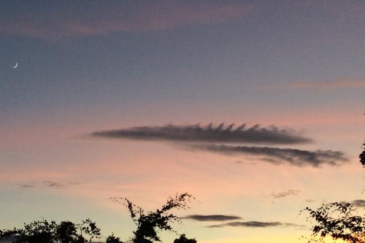
Clive Cooksey kindly sent us this photo of a "VERY rare cloud formation over Wilmslow again that lasts just seconds".

He said "It's called a Cirrus Kalvin-Helmholtz formation. It is caused by winds blowing harder at the upper level than the lower."

If you would like your photos of Wilmslow and the surrounding area to be considered for publication on wilmslow.co.uk then please email them to [email protected].

Tags:
Reader's Photo
Advertisement
Advertisement
Advertisement
Advertisement

Comments

Here's what readers have had to say so far. Why not add your thoughts below.

David Pearce
Wednesday 27th May 2020 at 7:21 pm
Stunning photo
Marcia McGrail
Wednesday 27th May 2020 at 10:44 pm
Is it a weather predictive phenomenom? In the same way certain clouds predict thunderstorms? (not that I am any kind of expert...just askin')
Vince Chadwick
Thursday 28th May 2020 at 12:47 pm
Hi Marcia. It isn't, as far as I know, weather predictive. The air mass over most of the UK has been unusually stable for several weeks with no significant 'weather', and looks to remain that way for a while yet. This is the result of us being under a stable high pressure system which is giving us clear skies and sunshine. The types of cloud which foretell weather are generally related to warm or cold fronts, or with an unstable atmosphere causing convective activity.

The Kalvin-Helmholtz cloud phenomena in the photograph is caused when layers of air in the atmosphere are moving at different speeds and the 'shear' between them deforms the cloud. Though such clouds are rare, the phenomena itself is common elsewhere in nature and is the cause, for instance, of waves being formed when a wind blows over the sea.