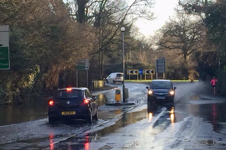
Cheshire East Council has confirmed it will being investigating the flooding issue on Alderley Road this weekend, which occurs each time there is heavy rain.
The main road into Wilmslow was flooded again at the weekend, for the twelfth time since last July.
Alderley Road will be closed from Harden Park Roundabout to Fulshaw Cross Roundabout on Saturday 22nd and Sunday 23rd February from 8am to 5pm whilst Cheshire East Highways carries out a drainage investigation.
Pedestrian access to any premises situated within the temporary closure will be maintained at all times whilst cyclists will be required to dismount.


Comments
Here's what readers have had to say so far. Why not add your thoughts below.
Presumably those involved will have familiarised themselves with documents on the CEC Planning Website associated with Application 19/3420M, in particular the ROC Consulting Flood Risk Assessment and Drainage Statement for Land East of the Royal London Campus; the Weetwood report of flood risk for the same site and the flood risk report for the proposed widening of Alderley Road and extension of the Whitehall Brook culvert?
Given that there have been increasingly frequent floods; where water cascades out of the Royal London site adjacent to the Whitehall Brook (rather than from the Brook itself) it may be worth revisiting the proposal to discharge surface water from the planned car parks on the RL site into "Watercourse A" the original course of the Brook, (which currently conveys water pumped from the by-pass) and into "Watercourse B" the new course of the Brook built to accommodate the construction of the by-pass). If not, presumably we can look forward to even more flooding?
Hopefully United Utilities and the Environment Agency will also be involved in the investigation.
Im sure the A34 A555 flood frequency would have been preventable with good design.. and once again the advice of experts and residents ignored..
Unravelling the mess is necessary before any new development is even considered.. IMO a CEC moratorium on any further development in these flood areas should be enforced .. 'everyone knows' but 'no one is listening' AGAIN !
https://www.theguardian.com/uk-news/2020/feb/17/uk-must-prepare-for-more-intense-storms-climate-scientists-say
Dr Marc Stutter,senior scientist James Hutton Institute in Aberdeen, “Flooding… problems were worsened by the degradation and concreting over of natural buffers, such as soil and green spaces. Infiltration and places to slow, store and filter water need to be planned back into landscapes to add resilience to floodwalls; the alternative is we risk raising the walls every few years.”
Dr Mohammad Heidarzadeh, head of coastal engineering and resilience Brunel University “ Non-structural solutions, such as managed retreat, sustainable drainage systems and public involvement, are vital….”
Long overdue
Like you, I can only assume that this is referring to "Whitehall Bridge Roundabout", which is the title used on all of the roadside traffic signage approaching this junction