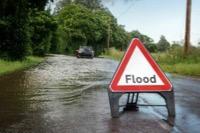
Cheshire East Council is urging communities, landowners and partners to come together to help tackle the scale and extent of future flooding incidents across the borough.
The recent spells of intense rainfall on already waterlogged ground, coupled with high river levels, has brought about unprecedented episodes of flooding across the borough.
The council is appealing to farmers and all landowners to clear ditches and culverts and improve land drainage. It is taking measures on its own land to improve drainage, where necessary, while the council's highways and environmental services teams have stepped up gully cleaning and street sweeping.
Across Cheshire East, it is estimated that more than 35,000 homes and business premises are located in areas where there is a recognised risk of flooding and all property owners have a responsibility to carry out their own measures to protect their homes and property without causing any interference with neighbouring properties.
Emergency planning teams from the council and other agencies are already working with communities affected by recent flooding events. Many residents and communities, including parish and town councils, provide support and help to each other, to build resilience, and share knowledge and strategies for dealing with flood emergencies.
The joint Cheshire emergency planning team works with town and parish councils to develop a community emergency plan to provide advice and direction, build resilience in communities and enable residents and councils to coordinate their own actions and responses.
Frank Jordan, Cheshire East Council's executive director for place, said: "It is important that we all work together to better prepare for the kind of flooding events we have experienced in the borough.
"We recognise that in some parts of the country, as well as in our borough, residents have experienced severe flooding incidents and have seen damage to their property and been forced to leave their homes or have been seriously inconvenienced by the closure of local roads.
"Naturally, we want to do all we can as a council and flood authority to try to minimise that risk here in Cheshire East but we would urge all home and property owners to check the flood risk map which shows the identified flood risk areas in the borough.
"We are working with a number of our partner agencies and organisations, including the Environment Agency, United Utilities, the Canal and River Trust, farmers and landowners.
"We are asking all landowners to take whatever steps they feel appropriate to help minimise the risk of flooding to properties, to roads and footways. If necessary, the council does have the power under the Land Drainage Act 1991, to compel landowners to do this."
Cheshire East Council continues to work within national planning policy guidelines regarding new development and flood risk to make sure that the risk of flooding is properly considered and reflected in planning decisions.
Click here for all information relating to flooding, how to prepare for flooding and the risk of flooding.


Comments
Here's what readers have had to say so far. Why not add your thoughts below.
http://bit.ly/2CRH6oZ
http://bit.ly/33WfM4W
1) In 2016, the planting of 40,000 trees above Pickering in North Yorkshire was credited with helping the frequently flooded town avert inundation during heavy rainfall
https://bit.ly/32Xs4bZ
2) According to Know Your Flood Risk, one in six homes in the UK at present is at risk of flooding
One factor that has contributed to the rise in flooding is the increase in impermeable surfaces with rapid urbanisation. Higher impermeable cover leads to increased surface runoff, a driver of flooding. More and more houses being built will only increase the percentage of impermeable cover, which will continue to exacerbate the issue. The land can no longer absorb rainfall if it is built over; instead, water runs off impermeable surfaces into drains which can become overwhelmed, and into rivers, increasing the flood risk in multiple areas. It is unlikely that old drainage systems will be able to cope with the increased burden, and thus sewer and surface water flooding will be more prevalent.
https://bit.ly/2QuI16U
Meanwhile, CEC Planning applications now continue this decimation of greenbelt locally, Each case considered individually and not cumulatively / collectively… How can that be right ? The impact compounds and the council are equally at fault for restitution if they don’t address this... Its really not rocket science !
So whilst the now ousted duplicitous incompetent Cllrs, have gone, they are still waving their churlish two fingered ‘Agincourt’ salute to the new sensible incumbents and residents,left suffering.. it is up to CEC to now address these floods, their causation collectively. A555 ,A34, Alderley Road, Styal Road, River Bollin .. just stop the development causing the problem set aside green belt and plant more trees ! Or shall they just built new builds on stilts like low lying United States and Tsunamia affected countries...