
With yellow weather warnings for rain remaining in place across Cheshire East for the next 24 hours drivers are being warned not to drive through heavy flood water.
A spokesperson for Cheshire Fire & Rescue Service said "Due to heavy rain fall we're advising drivers only make essential journeys and to be aware that a number of road closures are in place."
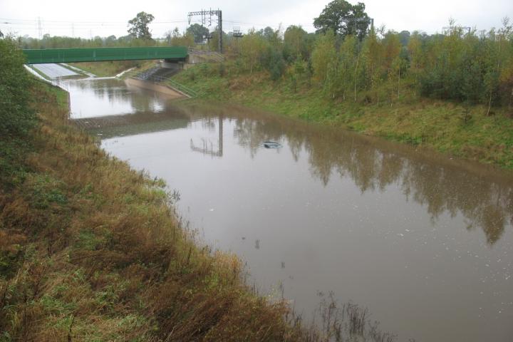
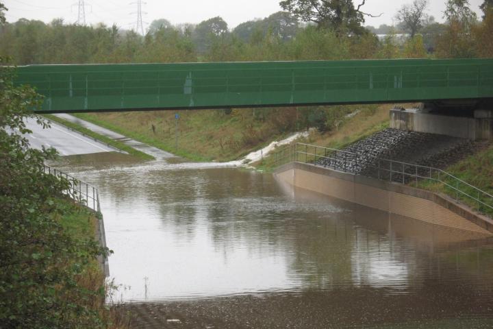
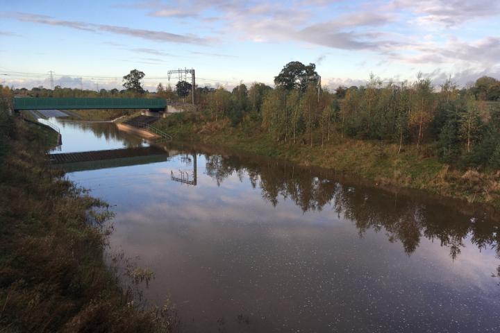
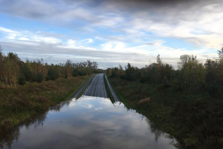
Many roads across East Cheshire are closed due to flooding including the A34 Alderley Edge Bypass (Melrose Way) as the carriageway is severely flooded.
The A34 Pendleton Way in Wilmslow is also closed in both directions between the Merlin Roundabout and Wilmslow High School.
Other local road closures include Styal Road and Stanneylands Road.
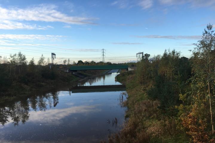
Nigel Dibben took these photos today from the bridge over the bypass. The third photo shows the water pouring onto the road off Welsh Row.
Updated 7pm Sunday 27th - A34 Melrose Way, Alderley Edge between Congleton Road, Nether Alderley and The Merlin Roundabout has now reopened and so has he A34 Pendleton Way, Wilmslow bypass.
Styal Road, Wilmslow has also now reopened however temporary traffic signals are in operation for safety in the vicinity of Twinnies Bridge.


Comments
Here's what readers have had to say so far. Why not add your thoughts below.
Residents of Wilmslow councillors from both the Wilmslow Town Council and the Cheshire East Council objected to the proposal. Part of the objection was based on an inadequate appraisal of flood risk in the general area.
David Jefferay the RoW Cheshire East councillor advised caution and deferral at committee for further considerations but was overruled.
Hot on the heels of this permission comes the Wilmslow Business Park application for another 185,000 square feet of speculative office space adjacent to the Royal London site directly accessed from the A34 link road.
Concreting over Green Belt in this way has consequences and there seems to be little or no appreciation of the cumulative affects of such extensive development areas. To consider flood risk, traffic congestion and air pollution in isolation, application by application is just irresponsible. Such environmental matters have no regard for the boundary red lines of individual applications.
The chairman of the SPB advised Councillor Jefferay that each application could only be considered in isolation.
This was clearly a mistake in relation to environmental matters and seems at odds with the Labour leader's avowed intent to place such environmental
issues front and foremost.
Row will continue to champion preservation of the Green Belt and challenge developments that are not carbon neutral and adversely affect environmental health.
Richard Armstead
Chair of RoW
We need to scrap both these lunatic schemes an plant trees.
It seems however that a recurring tendency for this section to flood suggests that the drainage capacity is inadequate. For such a new stretch of road to be found wanting in this regard is surely an issue to be urgently taken up with the responsible agencies engaged in the construction project for remedial action.
If such a reasonable observation & suggestion is considered to be naive & fancful then one has to wonder what was behind the balance between design inadequacies & short sighted cost savings which has resulted in this debacle.
Still it's good that at this time the Alderley bypass bypass is still functioning come rain or shine. Having made this remark one also has to wonder about the following: When Royal London is up & running with an increased headcount at their shiny new Aldeley Park offices how many of their northbound staff cars will turn right coming out of Alderley Park & clog up Alderley Edge village each weekday evening?
Development permissions are not about collecting brownie points they are about issues and planning policies. I think this was the focus of my comments.
Richard
Richard was just being transparent, so readers know he is part of an informed group, not just an interested individual.
Likewise, readers may not know you were a previous Conservative Wilmslow Town Councillor and Martin Watkins is currently its Conservative chairman.
Cllr Mark Goldsmith, RoW
New major roads such as the Congleton Link Road and the proposed Poynton Relief Road are now designed to withstand 1 in 100 year flood events (plus an allowance of +20% for climate change). The previously built bypasses (the A34 and even the more recent A6MARR) were only designed to withstand 1 in 30 year flood events, which are becoming more frequent than that.
The council is also investigating whether the reduction in river maintenance by the Environment Agency on the Bollin and Dean has contributed to some local flooding too. If our rivers can’t carry away as much water, then it backs up and causes flooding.
Finally, concreting over our green fields mean rain water runs into the system much quicker and the infrastructure gets overloaded. This is why we are pushing for a cumulative impact assessment of all the proposed developments around Royal London. Currently they all have individual ones that compare to the current situation, not the end result if all the building approved two years ago is completed.
Therefore, this is not just about how much rain we get, it’s also about where it all goes that is an issue.
It also underlines the importance of preserving our front gardens and other small urban green spaces; these small spaces also contribute to flood resilience as well as biodiversity and we have lost a lot of these in recent years with so much urban development. It's good to know that these issues are being taken seriously.
The problem with the Alderley bypass is that the section of road in question is lower than the surrounding area in order to pass under the railway. I think it was decided not to go over the rail line so as to minimise the noise levels that in Alderley Edge. So the road sits in a ‘pond’ that cannot perhaps be emptied by the pumps, as they do not have the capacity to cope with a large downpour - or have become downgraded as a result of blockage or partial failure. A solution therefore is to dig a big hole to act as a ‘pond’ in the area next to where this flooding will occur in a heavy downpour and install several pumps that can still cope to empty the ‘pond’ even though half of them become incapacitated. Such a ‘pond’ will act like a reservoir or buffer zone to take the excess water off the road whilst the downpour is happening and prevent flooding on the road. The only factor to decide is the size of the ‘pond’ and a satisfactory array of pumps [plural] to empty it. A decent barrier to prevent vehicles falling into the ‘pond’ would also be a good idea. Had this concept been designed into the bypass when it was built the soil from the pond might not have been needed to be taken very far as it could possibly have been used on another part of the road construction.