The Cheshire branch of Campaign for Rural England (CPRE) is calling on local residents to provide evidence that the surrounding Green Belt is of value and should be protected.
The campaign follows the appointment of Consultants Arup to appraise part of Cheshire East's Green Belt for their work on the Local Plan. Arup classified the Green Belt sites according to the following criteria:
• Major Contribution– contributes to the purpose in a strong and undeniable way, where removal of this parcel from the Green Belt would detrimentally undermine this purpose.
• Significant Contribution– contributes to the majority of the purpose but does not fulfil all elements.
• Contribution – makes a limited degree of contribution to the purpose, as some relationship has been identified between the parcel and the purpose.
• No Contribution- makes no contribution to the Green Belt purpose.
Around 400 parcels were identified, of which all were found to be making some contribution to the purposes of the Green Belt, whilst 82 sites were placed in the third category.
The report states that the sites identified as making a 'contribution' have the greatest potential to be considered for release for potential development due to their lower contribution to Green Belt function. It continues "It is expected that sites selected from the Green Belt parcel 'contribution' table will be prioritised for consideration to 'top up' non-Green Belt sites, in locations where demand is demonstrated as exceeding supply of non-Green Belt sites."
"Cheshire East Council can also consider release of parcels which have been assessed as having a higher weight and making a 'significant' or 'major' contribution to Green Belt purposes. Where Cheshire East Council considers taking this approach a greater case will need to be made for exceptional circumstances which outweighs the benefits of a potential site remaining in the Green Belt."
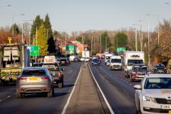
The 82 parcels of land identified as making a lesser contribution are clustered around Wilmslow and Macclesfield in the north of the district, and Scholar Green further south.
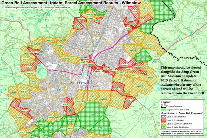
In Wilmslow 57 parcels of land were considered of which 2 were assessed to have a major contribution to the Green Belt whilst 34 were considered significant.
Twenty-one were placed in the contribution category, these include: land south of the River Dean and east of Handforth Road; land north of Adlington Road and south-west of Brown's Lane (this parcel is not designated as Green Belt but is included within this assessment for completeness); land to the south of Adlington Road to the rear of properties on Ridgeway and Hollies Lane; area of properties on Adlington Road, One Oak Lane, Hollies Lane and Ridgeway; land to the west of Adlington Road and north of the River Bollin; Bollin Valley east of A34 and north of River Bollin; Bollin Valley east of A34 and south of River Bollin; area of properties on Weston Road, Hough Lane and Prestbury Road and land south of Prestbury Road and north of Oak Hollow Farm.
Additionally these parcels of land were also felt to only make a contribution to the Green Belt: land east of Alderley Road including Royal London Campus; area of land between Alderley Road and the rear of properties on Fulshaw Park; land adjacent to the Wilmslow urban area between Clay Lane and Upcast Lane; land between Newgate Road and Greaves Road; the triangle of land bounded by Sandy Lane, Mobberley Road and Altrincham Road; area of land bounded by Altrincham Road and the rear of properties on King's Road and the small area of land bounded by Chancery Lane, Mill Street, Manchester Road and the River Bollin.
Plus the small area of land bounded by the River Bollin, railway line and Manchester Road; the small area of land bounded by the railway line and A34; Area of land east of River Dean and south of railway line; area of land north of the railway line and south of Stanneylands Road, to the west of properties on Stanneylands Drive and land to the west of Manchester Road and north of properties on Sefton Drive.
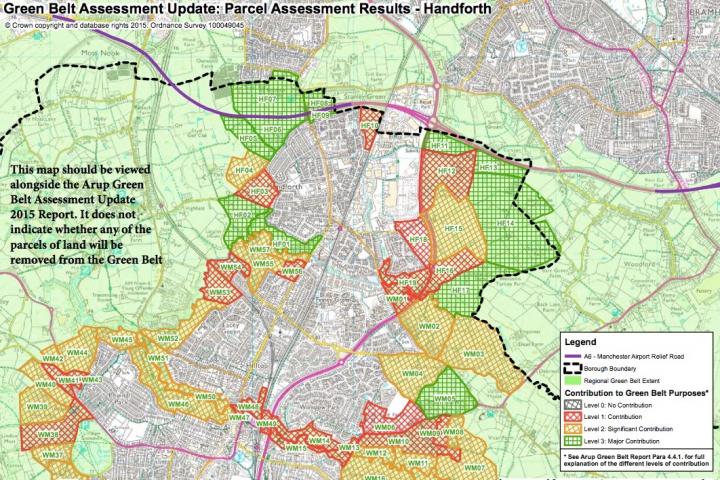
In Handforth 19 parcels of land were considered, of which 11 were assessed to have a major contribution to the Green Belt whilst 2 were considered significant.
Six were assessed as only having a contribution these include: land to the east of Lampson Crescent between Sagars Road and Clay Lane; the playing fields between Tatton Road and the railway line (south of A555); land to the east of A34 Handforth Bypass and south of Spath Lane; land north of Blossoms Lane and east of A34 Handforth Bypass; parcel of land by A34 Handforth Bypass south of Coppice Way and rear of existing properties on Hill Drive and surrounding roads (NB this parcel is not designated as Green Belt but is included within this assessment for completeness) and the area of land north of River Dean, east of Dean Road, south of properties on Woodlands Road and west of A34.
All of the 21 parcels of land in Alderley Edge included were assessed as being a major contribution or a significant contribution to the Green Belt.
CPRE Cheshire Chairman Andrew Needham said "There is a range of views about where development should take place - particularly in Cheshire East. We are not taking sides at this stage. The important thing is for relevant information to be understood by local people - particularly the ARUP report."
A map showing the sites considered within this report and the reasons for the classification of each site are available to read in Arup's report, which can be viewed online. The assessment of the individual parcels of land starts on page 122 of the report.
Andrew Needham added "As part of our campaign to protect the Green Belt, Cheshire Branch plans to collect evidence of its use for recreation, and photographs showing the beauty and tranquillity of these threatened parcels of land. If you live near to one or more of these sites, please visit and take photos where possible, and send in to Debbie Janney at the Branch Office (01606 835046) – preferably by email.


Comments
Here's what readers have had to say so far. Why not add your thoughts below.